Current topics in archaeology, cultural heritage & historic preservation

Showing posts with label indian. Show all posts

Sunday, November 22, 2009

Buffalo Bill's Defunct

Mystery, intrigue, petroglyphs, the Columbia River Gorge...what else could anyone interested in archaeology and fiction ask for?

Just check out the cover...stylized Pacific Northwest rock art galore.

Vancouver, WA author Sheila Simonson has blended local cultures and geography with some great characters in a book that I really enjoyed.

Simonson rearranges counties, towns, and cultures to produce a credible facsimile called "LaTouche County" which seems to include a good chunk of the western Gorge. She creates a pseudo Chinookan tribe called the "Klalo" and names the county seat after them. Tribal members, including the female chief, have key roles in the story.

Stolen artifacts, murder, clashing cultures, interesting characters and familiar places combine for an engaging read. You can learn more about the author and her books at her website. The book is available at Amazon and Powells.com (for well under $15) and, I assume, at local bookstores.

Might make a great Christmas gift!

###

Saturday, October 24, 2009

Cupules on the Columbia

Upriver of Vancouver, Washington the Columbia River bank is edged with thousands of rounded basalt boulders.

Ripped from the up-river bedrock thousands of years ago by massive ice-age floods these rocks, once part of the volcanic landscape, were shaped as they rolled downstream in massive torrents of water.

Over a hundred floods, that for a time carried more water than all the other rivers on earth combined, gouged the earth to form what is now called the Columbia River Gorge. The boulders are all that remain of over 50 cubic miles of dirt and rock that were violently flushed into the Pacific.


Rounded boulders shaped by the Missoula Floods.

In the Vancouver area alone, over a hundred of these boulders hold ancient Indian rock art. The most common marks left by the prehistoric people are cupules...thousands and thousands of cupules.

Some individual rocks hold several hundred of these distinctive marks...small (1"-4" across) cup-shaped indentations in the rock that are formed by pounding a hand-held "hammer stone" repetitively against the surface of the boulder.


Why make a cupule? Why do some rocks hold only a single cupule but others have hundreds of these mysterious dimples?

Theories abound...but two seem to hold the most promise.

One, the "Baby Rock" theory holds that ancient women sought the rock powder that was produced as the cupule was formed. The powder was believed to hold spiritual power that, when eaten or rubbed on the body, would help a woman become pregnant. There is significant evidence from similar sites in Northern California to support this idea.

But was it the same along the Columbia?

A second theory proposes that the cupules were formed by Salmon shaman. These shamans were important spiritual leaders whose role it was to call the schools of Salmon back from the ocean every year so that the people could eat, live, and prosper. The Salmon were thought to hear the shaman pounding on the rock and return to where they could be caught to nourish the tribe.

In either case, the point was not the cupule itself...cupules were simply by-products of another important activity.

Both ideas are intriguing...but do they reflect reality? Trying to look into the minds of ancient people is fascinating. Physical evidence can be studied, ethnography can be mined, present day descendants can be interviewed and, of course, opinions abound...but to a significant extent the mystery remains...who were the ancient people of the Columbia, what were their beliefs, and what are the true meanings of the art and the symbols they left behind?

Of course, partial answers can be found to all of these questions, but the true richness of a prehistoric culture can never be fully experienced...and that's a big part of what makes it so appealing.
Temanawas Rock overlooks the Columbia River near Vancouver, WA

As interesting as they are, cupules aren't the only rock art along the lower Columbia River. Stay tuned and we'll continue to explore!


Thursday, September 24, 2009

Kennewick Man II: Anthropologist Argues That Corps of Engineers Acted Properly

In a Seattle Times opinion piece Dr. James Nason, a retired University of Washington anthropology professor and emeritus curator at the Burke Museum (where the original Kennewick Man is kept), argues that the Corps of Engineers is properly handling the recently found remains.

There are some very interesting comments at the end of the article.

Check it out at: Corps Acted Properly

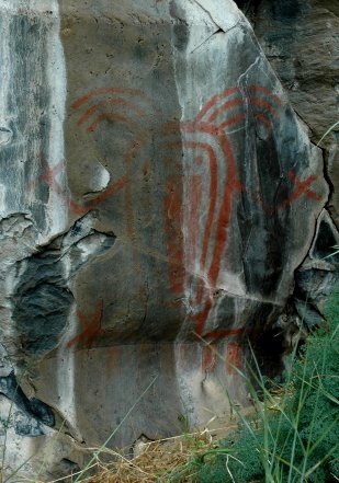
(Rock art pictured is near Kennewick, WA).

###

Tuesday, September 15, 2009

Kennewick Man II Debate Continues

Two bits of recent news on the newly discovered Kennewick Man II bones...

From the Tri-City Herald, Sept. 15, 2009

Anthropologist to study jawbone found in river

The Army Corps of Engineers plans to hire an independent anthropologist to study a jawbone found in the Columbia River in August, said Corps spokesman Joseph Saxon.

The lower jawbone with two teeth was turned over to the Army Corps because it was found on the agency's land in an undisclosed location on the river. The 9,300-year-old bones of Kennewick Man also were found on the Columbia River...

Read the whole story at: Tri-City Herald: Sept. 15, 2009


From the Seattle Times, Sept. 15, 2009

Did U.S. Corps of Engineers learn nothing from Kennewick Man?

The U.S. Army Corps of Engineers apparently didn't learn much from the experience of the Kennewick Man case, these guest columnists write. The initial Corps decision to turn a jawbone found on the shores of the Columbia over to tribes without establishing a definitive connection is misguided.

GOVERNMENT agencies are often slow learners. A case in point is the U.S. Army Corps of Engineers' process for protecting human skeletal remains found on Corps-managed federal land.

Recently a partial human jawbone and two teeth were recovered from the Columbia River not far from where the 9,400-year-old Kennewick Man skeleton was found in 1996. Based solely upon visual inspection of these remains, the Army Corps declared them to be Native American, which puts them on a fast track for transfer to local tribes...

Read the whole story at: Seattle Times: Sept. 15, 2009


Sunday, September 13, 2009

Ancient Images: Deschutes River Rock Art Video

The view from this small Oregon rock shelter is gorgeous...coupled with its spiritual energy it must have inspired hundreds of generations of visitors as they sought its power.


Located above the fast flowing Deschutes River (a tributary of the Columbia) in central Oregon, the shallow cave is filled with rock art, mostly red or white pictographs.


Both vision quest and shamanistic images are found in the shelter.

Polished smooth by millennia of use, a large flat rock surface in the center of the shelter provides a perfect spot to sit or lay as you seek interaction with spirit helpers or mysterious forces.

You can share a little of this ancient experience in the video below. (Remember to turn on your sound, click the "full-screen" option for a larger view of the video. The photos in this post can also be enlarged by clicking on them).


(Please be aware that YouTube will show you several "recommended videos" at the bottom of the screen when Ancient Images is over. Some of these are interesting, others may be completely inappropriate. Sadly I have no influence or control over what YouTube chooses to promote at the end of my video. Viewer beware.).

Please remember to preserve and protect unique and irreplaceable cultural treasures like this small rock shelter. It is still sacred to the people who used it...and continue to use it even now.

This rock art has been here for hundreds, if not thousands, of years...with your help it can still be here thousands of years from now.

###

Friday, September 4, 2009

Rock Art Site Etiquette

Visiting a rock art site can be a great experience!

If you're privileged to go to a site here are some guidelines that will help you protect the site while you enjoy it.

  • Treat the site and the rock art with the same respect you would give a religious or sacred place…that’s what it is.
  • Don’t touch the images. The oils from your skin will damage them over time and the abrasion of your fingers can actually remove images from the rock.
  • Don’t remove anything from the site. That cigarette at the foot of the cliff may not be litter but a tobacco offering; that dollar bill was not “lost”…they may have been left by modern Indians to honor the spiritual power of the rock art (of course if you're sure its litter, take it out with you).
  • If there is a trail stay on it. If there is not a trail try not to make one.
  • Don’t trespass on private property.
  • Don’t share the location of non-public sites with others.
  • Don’t make “rubbings” or “contact prints”. This very often causes irreparable harm.
  • Do take photographs or make sketches of the images and feel free to show them to your friends and family.
  • Final Note: Have a good time, be safe, and act responsibly. Take time to enjoy the setting, the culture, the fresh air… and remember, its about appreciating, respecting, and preserving prehistoric rock art that is sacred to the people who made it.
The rock art has been there for thousands of years… with your help it can still be there a thousand years from now.

(The images above are from rock art sites along the Columbia River in Washington and Oregon).

Friday, August 21, 2009

Creativity Unleashed!

The Washougal pedestrian tunnel itself is completely engineered and construction is well underway...but what about the Columbia Plateau rock-art-inspired panels that are a major part of its creative design?

Well, I'm here to tell you that the creative energy of the Petroglyph Team's student interns was released BIG-TIME at our most recent meeting.

Each of the Washougal High students on the Team had been chartered by artist Rex Ziak with creating a personal vision of the rock art that would fill the tunnel.

Students Emily Carroll, Kirstin Peterson, Patrick McCarthy, Sarah Walker, Chloe Kilgore, Brian Price, Paige Wade, Chris Norton, and Heather Mattole each prepared a detailed creative plan for the 7 basalt slabs that will line one wall of the tunnel.

I'm not sure what I expected when the assignment was given out...but whatever it was, reality significantly exceeded any expectations I might have dreamed about! You would think that in a group of 9 busy high school students there would be a few creative duds...you would be wrong!

Designs (above and below) laid out for review...

These kids, none trained in art as far as I know, each came up with an innovative, creative artistic plan for the tunnel. Honestly I think all the adults in the room, including Rex, were amazed. The deep thought and artistic concepts were inspiring.


Emily Carroll, Brian Price, and Kirsten Walker (above) present their designs.

Patrick McCarthy commands the attention of the audience, including artist Rex Ziak (center left), as he presents his vision for the tunnel's rock art.


Paige Wade, Chris Norton, and Chloe Kilgore explain their designs.

Heather Mattole (left and center below) captures the imaginations of Team members Patrick McCarthy, Paige Wade, Chloe Kilgore, Rix Ziak and Robert David (left to right).


Now the focal point of the artistic process moves to Rex Ziak. He will consider the ideas of the students along with his own creative thoughts and begin to finalize the images that will make this tunnel anything but pedestrian.

Stay tuned...


###

Saturday, August 15, 2009

"Passage to the Columbia"

...those words capture the City of Washougal's vision for the new pedestrian tunnel that will re-link the core of the city to its waterfront on the Columbia River for the first time in over 40 years.

At the same time the tunnel (location outlined in yellow below) will honor the Indian tribes of the region with a display of important rock art images from across the Columbia Plateau.

When complete the tunnel will burrow under the buzzing traffic on Washington's Highway 14 and open into popular Steamboat Park, whose southern edge extends into the river with a series of popular docks used for fishing and boating.

Walkers who explore the length of the tunnel will find a series of 7 massive native basalt slabs (each weighing approximately 2,800 pounds) engraved with representations of symbols found in Plateau petroglyphs and pictographs.

The City has assembled a group, known as "the Petroglyph Team" to research and identify the images that will eventually grace the tunnel. Lead by artist Rex Ziak (at left with basalt slab) and City manager Nabiel Shawa the team includes students from Washougal High, Councilwoman Molly Coston, Parks Manager Suzanne Bachelder, parent Margaret McCarthy, rock art scholar and Klamath tribal member Robert David, myself and other volunteers.

On Friday, August 14, 2009 the Team visited the stone yard where the basalt slabs are being prepared . We saw a huge rock saw cutting one of our slabs from an enormous crystal of basalt and watched a skilled rock carver demonstrate how the images will be engraved into the surface of the stone.


The Team has looked at hundreds of images and has narrowed the choices down to about 75 finalists, a few of which are included here.

Construction of the tunnel is well underway although the actual slice through Hwy 14 has not yet occurred. Its pretty amazing how much prep work it takes to create something that seems so simple...smoothing the landscape, running utility lines under the street, preparing the surface outside the tunnel for human traffic, and more...all needing to be completed with a minimum of disruption to the traffic streaming by on the highway.


Stay tuned and watch the evolution of the tunnel and its Native American-inspired art...

###

Saturday, August 1, 2009

Preserved for Over 1000 Years! Range Creek Ranch, Utah

300 archaeological sites, in one 4200 acre area, untouched by man for over 1000 years?

Sounds unlikely, but that's exactly what exists on Range Creek Ranch in a remote part of Utah. Owned and protected by the Wilcox family for generations this incredibly well-preserved piece of history was sold by Waldo Wilcox (pictured below courtesy of Great Outdoors.com) to the Trust for Public Lands in 2001 and then deeded to the State of Utah.

Native American pithouse villages, granaries high on cliff walls, hundreds rock art images, and seemingly endless scatters of stone tools, beads, and ceramics are spread across the landscape. Credited to the ancient Fremont Culture these artifacts are essentially pristine...as if the Fremont people had walked away over 1000 years ago, never to return.


In its best episode to date Time Team America spent 3 days working with lead archaeologist, Duncan Metcalfe, of the Utah Museum of Natural History. Just below is a short preview video from Time Team America. (click here to watch the whole Ranch Creek Time Team Episode).


To learn more about Range Creek Ranch and its fascinating story check out...


Secrets of the Range Creek Ranch, Smithsonian Magazine

The Lost World of Range Creek, Great Outdoor.com

Secrets of the Lost Canyon, KUED-University of Utah

Range Creek, Utah Division of Wildlife Resources

###

Saturday, July 25, 2009

Chinook Nation Progresses as Leaders Testify in Washington D.C.

July 15, 2009 may be recorded as one of the most important days in Chinook Indian Nation history.

The day that Chinook leaders testified before the House Committee on Natural Resources in Washington D.C. in a continuing effort to regain federal recognition. The Natural Resources Committee oversees Native American issues and will be influential in consideration of HR 3084, the Chinook Nation Restoration Act.

The 2,700 member tribe was represented by Council Chairman Ray Gardner (pictured here courtesy The Chinook Observer), Council Member and Hereditary Chief Phil Hawks and Council Member Sam Robinson. U.S. Representative Brian Baird (WA) also spoke in favor of the Chinook Nation.

The next step in the recognition process will occur about two weeks after the hearing when Rep. Baird plans to ask the committee to prepare the bill for consideration by the whole House of Representatives. A vote is said to be possible later this summer.

An excellent article on the hearings can be viewed at The Chinook Observer newspaper website.

Your support will be very influential to the success of the process. Please contact your senators and representatives and express support for HR 3084, The Chinook Nation Restoration Act. You can easily find and email your elected officials at Contacting Congress.

Video of Chairman Gardner testifying (click here)


Video of Representative Baird Speaking to Committee (click here)


###

Saturday, July 18, 2009

Petroglyph Team Seeks Images at Columbia Hills State Park


Members of the Washougal Petroglyph Team, lead by artist Rex Ziak (at left in photo), headed to Columbia Hills State Park (formerly Horsethief Lake State Park) on Friday, July 17 to gain experience with rock art and to begin gathering examples of images that could be useful in their project (see previous post for project details, click on any photo to get an enlarged version).

Washougal has broken ground on the new pedestrian tunnel that will re-connect the city to its waterfront. Its not much to look at yet...

...but Rex's concept of including Columbia Plateau rock art at the tunnel's entrance should make it a real landmark.

About 7:45 am the team drove east toward Columbia Hills. By 9:00 it was already warm, headed for hot, and there was a high overcast. Not the best conditions for viewing rock art as we found out when we made a short stop in Stevenson to see the large, intensely carved boulder that was moved there from Skamania Landing years ago.

The light was flat and the rock art was almost invisible. For many of the students this was their first exposure to "real" rock art and it was a tough one...but after a few clues and a lot of squinting everyone began to see the symbols and cupules carved into the boulder (the photo at right was taken on a different, rainy day when the rock art was offering itself for easy viewing).

An hour or so later we arrived at Columbia Hills, checked in with the friendly rangers and headed for the parking lot where our tour would begin. We joined our guide, Mike, a park aide (below in green shirt with French foreign legion hat) and several other "civilians" (meaning people who weren't Petroglyph Team members).
Mike gave us an excellent and inspired introduction. We all appreciated both his passion and knowledge about the rock art of the area.

As the sun beat down and the temperature rose above 90 we trekked into the rimrock and down the trail to get up-close and personal with some of the most incredible rock art in North America.

We quickly started to see pictographs and petroglyphs on the basalt cliffs to our North. Some were more visible than others...but then that's the way it always is with rock art.

Mike stopped often and explained to everyone what they were seeing. All of us were riveted by the images and by the information that was shared about the ancient cultures and traditions that have been part of our region for so many thousands of years.


Here are a few of the many, many rock art images we were priviledged to see...


So our guide, Mike, lead us across the landscape, pointing out rock art, sharing knowledge, gently herding us along. After about an hour or so we walked up a hill, around a corner and...BANG!

...Tsagaglalal...She Who Watches...stunning...bigger than life...staring across history!

So what better place to end the tour? The team experienced rock art first-hand, examined and photographed many candidate images for the tunnel project, gained a wealth of knowledge and an increased appreciation and respect for another culture.

All in all, not a bad day's work!

Thanks to Nabiel Shawa, Rex Ziak, and everyone who made the trip possible.
###