For tickets email: culturewatch@gmail.com

Saturday, June 7, 2014
Monday, February 25, 2013
40,000 Years of Life & Death: Excavations in Spain's El Miron Cave
The Oregon Archaeological Society is pleased to sponsor the March 5, 2013 lecture titled: "40,000 Years of Life and Death in a Spanish Cave: Excavations in El Miron, Cantabria."

The featured
speaker is the distinguished Dr. Lawrence Guy Straus, the Leslie Spier
Distinguished Professor of Anthropology at the University of New Mexico College
of Arts and Sciences.
El Miron
Cave, located in the Cantabrian Cordillera in Spain has been excavated by
Professor Straus and a Spanish colleague since 1996. Scientifically
discovered in 1903, but ignored by archaeologists despite being surrounded by
cave art sites, El Miron is a large cave with a strategic location. First
visited by Straus in 1973, it has yielded results beyond his wildest
expectations.
The cultural sequence begins in the late Middle Paleolithic
and continues through evidence of Medieval visits, with radiocarbon dates
ranging from 41,000 BP to AD 1400. As the surrounding environment changed, the
evidence of human use of the cave also changed.
The
site has been the subject of numerous multidisciplinary studies of the climate,
landscapes, human technology, subsistence, and artistic activity that have resulted
in dozens of publications in Europe and the U.S. Major discoveries have included
dated portable art objects, rock engravings, an associated human burial,
evidence of human occupation and livestock stabling, and ceramic and metal
technology.
Straus has
conducted excavations in Spain, France, Portugal, and Belgium, principally at
Upper Paleolithic (but also Middle Paleolithic, Mesolithic and Neolithic)
sites. He is particularly interested in human adaptations to the diverse
and changing environments of the Last Glacial in Western Europe.
He has authored
numerous publications and has been the Editor-in-Chief of the Journal of
Anthropological Research since 1995. He has been given lifetime achievement
awards by the Stone Age Institute at Indiana University and the Sociedad
Prehistorica de Cantabria, and has held offices in the international unions for
Quaternary Research (INQUA) and Pre- and Proto-historic Sciences (UISPP).
The presentation is at Oregon Museum of Science and Industry (OMSI) is free and open to the public. A general business meeting begins at 7 PM, followed by the lecture.
See www.oregonarchaeological.org/events or call 503-727-3507 for more information.
The presentation is at Oregon Museum of Science and Industry (OMSI) is free and open to the public. A general business meeting begins at 7 PM, followed by the lecture.
See www.oregonarchaeological.org/events or call 503-727-3507 for more information.
Tuesday, January 1, 2013
Petroglyph Canyon Historic Photos
 |
| Large wall of rock art at Petroglyph Canyon (Willis Vail Photo, 1905. © Old Oregon Photos.) |

View of Petroglyph Canyon location. Columbia Hills State Park is at the red "You Are Here" dot (image courtesy of Washington State Parks)
Petroglyph Canyon was reported to have one of the largest concentrations of Indian rock art in North America before it was largely submerged in the pool behind The Dalles Dam (photo below) in 1957. Today much of the rock art, and the canyon itself, lie hidden beneath the waters of Horsethief Lake and the Columbia River at Columbia Hills State Park near Dallesport, WA.

We recently came across a website (www.oldoregonphotos.com) that displays (and sells) historic photographs. John Klatt, who owns the Old Oregon website, has graciously allowed CultureWatch NW to reproduce some very old photos of Columbia Gorge rock art. (All historic photos in this post are © Old Oregon Photos).
As the giant hydroelectric generation dams were built on the Columbia River beginning in the 1930's many Native American cultural areas, including rock art sites, were flooded by the large lakes that formed behind them. Photographers, professional and amateur, scrambled to record the ancient images before they disappeared.
By the way, if you have old photos of rock art from the Columbia Gorge and are willing to share them we would love to hear from you! Just send an email to culturewatch@gmail.com.
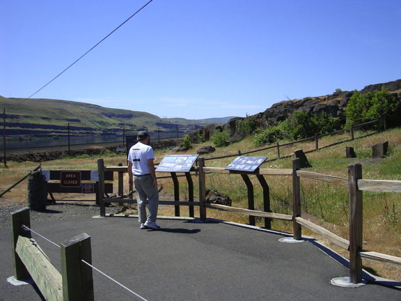
A number of petroglyphs and pictographs were actually "salvaged" by being physically removed from areas about to be submerged. Some of these rescued boulders, including a number of those shown in the old Benjamin Markham photos in this article, can be seen today along the Temani Peshwa Trail (photo below) at Columbia Hills State Park and at the Ginkgo Petrified Forest Recreation Area near Vantage, WA.

So let's take a look at the old photos! When available we've included both a historic picture (black and white) and a modern photo (color) so you can see how the rock art has changed in the last 75-100 years.
As the giant hydroelectric generation dams were built on the Columbia River beginning in the 1930's many Native American cultural areas, including rock art sites, were flooded by the large lakes that formed behind them. Photographers, professional and amateur, scrambled to record the ancient images before they disappeared.
By the way, if you have old photos of rock art from the Columbia Gorge and are willing to share them we would love to hear from you! Just send an email to culturewatch@gmail.com.
A number of petroglyphs and pictographs were actually "salvaged" by being physically removed from areas about to be submerged. Some of these rescued boulders, including a number of those shown in the old Benjamin Markham photos in this article, can be seen today along the Temani Peshwa Trail (photo below) at Columbia Hills State Park and at the Ginkgo Petrified Forest Recreation Area near Vantage, WA.
So let's take a look at the old photos! When available we've included both a historic picture (black and white) and a modern photo (color) so you can see how the rock art has changed in the last 75-100 years.
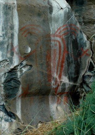
The photo on the left below was taken by Benjamin Markham in the 1920's. It shows the panel of petroglyphs in situ, still part of the cliff wall at Petroglyph Canyon. The same panel is visible at center left in the Willis Vail photo above. On the right below is the salvaged panel, now located on the Temani Peshwa Trail.


You will notice that the contrast between the petroglyphs and the background rock is much greater in the old photos. Historically it was a common practice to color or outline rock art with white chalk to make the images show up clearly in photos. This practice is now regarded as vandalism because it may take decades for the chalk to disappear.


You will notice that the contrast between the petroglyphs and the background rock is much greater in the old photos. Historically it was a common practice to color or outline rock art with white chalk to make the images show up clearly in photos. This practice is now regarded as vandalism because it may take decades for the chalk to disappear.

Images in situ at Petroglyph Canyon.
Markham Photo.
| ||
 
Images in situ at Petroglyph Canyon (at left above, Markham Photo circa 1920's) and as they looks today on the Temani Peshwa Trail at Columbia Hills State Park.

The photo on the left (attributed to Markham but unsigned) was taken near Wishram, WA. A modern photo shows the beautiful color of the images which are a combination of petroglyphs and pictographs (painted on the rock surface).

The two photos below were also taken by Markham
in the 1920's. Unfortunately we don't have any modern photos to compare them with. The image on the left was taken in Petroglyph Canyon and is now assumed to be submerged. The other was taken at a rock art site in Sherman County, Oregon.   Check out the historic photos at www.oldoregonphotos.com and when the weather warms up (after April 1) head out to Columbia Hills State Park where you can take a self-guided tour of the Tamani Peshwa Trail (whenever the park is open) and also a free guided tour of the other extensive rock art sites at the park (reservation required for the free tour, there is a small fee to enter the park). |

Subscribe to:
Posts (Atom)